Seven Years War (1756-1763). Map of the Battle of Lutterberg (October 10, 1758). French troops, led by Prince Soubise, defeated a contingent of Hanoverian soldiers and Hessian mercenaries, commanded by General Christoph Ludwig von Oberg. Published in 1765 by the cartographer Jean de Beaurain (1696-1771) as an illustration of his Great Map of Germany, with the events that took place during the Seven Years War. Allied army in red and the French army in blue. Etching and engraving. French edition, 1765. Military Historical Library of Barcelona (Biblioteca Histórico Militar de Barcelona). Catalonia. Spain. Author: Jean de Beaurain (1696-1771). French geographer.
This image has restrictions and cannot be purchased online. Get in touch for more details.
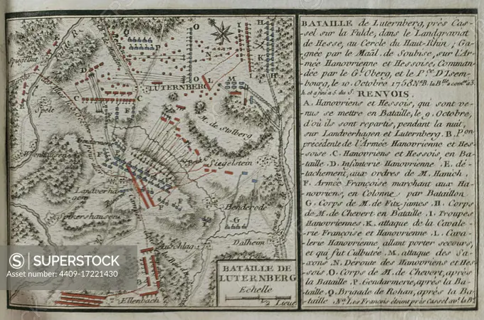
SuperStock offers millions of photos, videos, and stock assets to creatives around the world. This image of Seven Years War (1756-1763). Map of the Battle of Lutterberg (October 10, 1758). French troops, led by Prince Soubise, defeated a contingent of Hanoverian soldiers and Hessian mercenaries, commanded by General Christoph Ludwig von Oberg. Published in 1765 by the cartographer Jean de Beaurain (1696-1771) as an illustration of his Great Map of Germany, with the events that took place during the Seven Years War. Allied army in red and the French army in blue. Etching and engraving. French edition, 1765. Military Historical Library of Barcelona (Biblioteca Histórico Militar de Barcelona). Catalonia. Spain. Author: Jean de Beaurain (1696-1771). French geographer. by Album/Prisma/Album Archivo is available for licensing today.
DETAILS
Image Number: 4409-17221430Rights ManagedCredit Line:Album/Prisma/Album Archivo/SuperStockCollection:Album Archivo Contributor:Album / Prisma Model Release:NoProperty Release:NoResolution:4677×3103